AMapGeoFenceDistrictRegion Class Reference
行政区划地理围栏(since 2.3.0) More...
#import <AMapGeoFenceRegionObj.h>
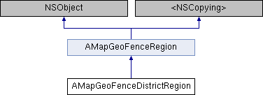
Inheritance diagram for AMapGeoFenceDistrictRegion:
Properties | |
| AMapLocationDistrictItem * | districtItem |
| 行政区域信息 More... | |
| NSArray< NSArray< AMapLocationPoint * > * > * | polylinePoints |
| 行政区域轮廓坐标点,每个行政区可能有多个模块,每个模块的坐标点数组由AMapLocationPoint构成 More... | |
 Properties inherited from AMapGeoFenceRegion Properties inherited from AMapGeoFenceRegion | |
| NSString * | identifier |
| AMapGeoFenceRegion的唯一标识符 More... | |
| NSString * | customID |
| 用户自定义ID,可为nil。 More... | |
| AMapGeoFenceRegionStatus | fenceStatus |
| 坐标点和围栏的关系,比如用户的位置和围栏的关系 More... | |
| AMapGeoFenceRegionType | regionType |
| 用户自定义ID,可为nil。 More... | |
| CLLocation * | currentLocation |
| 缓存最近获取的定位信息,可能会存在延时,可为nil,会在获取定位时更新 More... | |
Detailed Description
行政区划地理围栏(since 2.3.0)
Property Documentation
◆ districtItem
|
readnonatomicstrong |
行政区域信息
◆ polylinePoints
|
readnonatomiccopy |
行政区域轮廓坐标点,每个行政区可能有多个模块,每个模块的坐标点数组由AMapLocationPoint构成
The documentation for this class was generated from the following file: