Loading...
Searching...
No Matches
MAPolygon Class Reference
此类用于定义一个由多个点组成的闭合多边形, 点与点之间按顺序尾部相连, 第一个点与最后一个点相连, 通常MAPolygon是MAPolygonView的model More...
#import <MAPolygon.h>
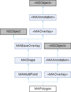
Inheritance diagram for MAPolygon:

Instance Methods | |
| (BOOL) | - setPolygonWithPoints:count: |
| 重新设置多边形顶点. since 5.0.0 | |
| (BOOL) | - setPolygonWithCoordinates:count: |
| 重新设置多边形顶点. since 5.0.0 | |
 Instance Methods inherited from MAMultiPoint Instance Methods inherited from MAMultiPoint | |
| (void) | - getCoordinates:range: |
| 将内部的坐标点数据转化为经纬度坐标并拷贝到coords内存中 | |
 Instance Methods inherited from <MAOverlay> Instance Methods inherited from <MAOverlay> | |
| (CLLocationCoordinate2D) | - coordinate |
| 返回区域中心坐标 | |
| (MAMapRect) | - boundingMapRect |
| 区域外接矩形 | |
 Instance Methods inherited from <MAAnnotation> Instance Methods inherited from <MAAnnotation> | |
| (void) | - setCoordinate: |
| 设置标注的坐标,在拖拽时会被调用. | |
Class Methods | |
| (instancetype) | + polygonWithCoordinates:count: |
| 根据经纬度坐标数据生成闭合多边形 | |
| (instancetype) | + polygonWithPoints:count: |
| 根据map point数据生成多边形 | |
Properties | |
| NSArray< id< MAOverlay > > * | hollowShapes |
| 设置中空区域,用来创建中间带空洞的复杂图形。注意:传入的overlay只支持MAPolgon类型和MACircle类型,不支持与polygon边相交或在polygon外部,不支持hollowShapes彼此间相交,和空洞顺序有关,不支持嵌套. since 5.5.0 | |
 Properties inherited from MAMultiPoint Properties inherited from MAMultiPoint | |
| MAMapPoint * | points |
| 坐标点数组 | |
| NSUInteger | pointCount |
| 坐标点的个数 | |
| BOOL | cross180Longitude |
| 是否跨越180度经度线,默认NO since 6.4.0 | |
 Properties inherited from MAShape Properties inherited from MAShape | |
| NSString * | title |
| 标题 | |
| NSString * | subtitle |
| 副标题 | |
 Properties inherited from MABaseOverlay Properties inherited from MABaseOverlay | |
| CLLocationCoordinate2D | coordinate |
| 返回区域中心坐标 | |
| MAMapRect | boundingMapRect |
| 区域外接矩形 | |
| double | altitude |
| 海拔,单位米,默认0 | |
 Properties inherited from <MAAnnotation> Properties inherited from <MAAnnotation> | |
| CLLocationCoordinate2D | coordinate |
| 标注view中心坐标 | |
| NSString * | title |
| annotation标题 | |
| NSString * | subtitle |
| annotation副标题 | |
| double | altitude |
| annotation海拔高度,单位米,默认0 | |
Additional Inherited Members | |
 Protected Attributes inherited from MAShape Protected Attributes inherited from MAShape | |
| NSString * | _title |
| 标题 | |
| NSString * | _subtitle |
| 副标题 | |
 Protected Attributes inherited from MABaseOverlay Protected Attributes inherited from MABaseOverlay | |
| double | _altitude |
| 海拔 | |
Detailed Description
此类用于定义一个由多个点组成的闭合多边形, 点与点之间按顺序尾部相连, 第一个点与最后一个点相连, 通常MAPolygon是MAPolygonView的model
Method Documentation
◆ polygonWithCoordinates:count:
| + (instancetype) polygonWithCoordinates: | (CLLocationCoordinate2D *) | coords | |
| count: | (NSUInteger) | count | |
根据经纬度坐标数据生成闭合多边形
- Parameters
-
coords 经纬度坐标点数据,coords对应的内存会拷贝,调用者负责该内存的释放 count 经纬度坐标点数组个数
- Returns
- 新生成的多边形
◆ polygonWithPoints:count:
| + (instancetype) polygonWithPoints: | (MAMapPoint *) | points | |
| count: | (NSUInteger) | count | |
根据map point数据生成多边形
- Parameters
-
points map point数据,points对应的内存会拷贝,调用者负责该内存的释放 count 点的个数
- Returns
- 新生成的多边形
◆ setPolygonWithCoordinates:count:
| - (BOOL) setPolygonWithCoordinates: | (CLLocationCoordinate2D *) | coords | |
| count: | (NSInteger) | count | |
重新设置多边形顶点. since 5.0.0
- Parameters
-
coords 指定的经纬度坐标点数组, C数组,内部会做copy,调用者负责内存管理 count 坐标点的个数
- Returns
- 是否设置成功
◆ setPolygonWithPoints:count:
| - (BOOL) setPolygonWithPoints: | (MAMapPoint *) | points | |
| count: | (NSInteger) | count | |
重新设置多边形顶点. since 5.0.0
- Parameters
-
points 指定的直角坐标点数组, C数组,内部会做copy,调用者负责内存管理 count 坐标点的个数
- Returns
- 是否设置成功
Property Documentation
◆ hollowShapes
|
readwritenonatomicstrong |
设置中空区域,用来创建中间带空洞的复杂图形。注意:传入的overlay只支持MAPolgon类型和MACircle类型,不支持与polygon边相交或在polygon外部,不支持hollowShapes彼此间相交,和空洞顺序有关,不支持嵌套. since 5.5.0
The documentation for this class was generated from the following file: